


Chartreuse Sapey crêtes saint Eynard Emeindras

c.gourme
User
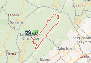

Length
12.4 km

Max alt
1497 m

Uphill gradient
622 m
Km-Effort
21 km

Min alt
992 m

Downhill gradient
621 m
Boucle
Yes
Creation date :
2023-03-16 07:51:47.0
Updated on :
2023-03-16 19:57:32.893
5h33
Difficulty : Medium

FREE GPS app for hiking
 SityTrail
IGN / Geographical institutes
SityTrail Plus
The world is yours!
About
Trail Walking of 12.4 km to be discovered at Auvergne-Rhône-Alpes, Isère, Le Sappey-en-Chartreuse. This trail is proposed by c.gourme.
Description
Suivre au début, les traces du GR
Bien rester en haut des crêtes sur le parcours.
Positioning
Country:
France
Region :
Auvergne-Rhône-Alpes
Department/Province :
Isère
Municipality :
Le Sappey-en-Chartreuse
Location:
Unknown
Start:(Dec)
Start:(UTM)
718044 ; 5015438 (31T) N.
Comments